Reminiscences of my version of Alta’s 75th ski season

I have come to really love this place. Skiing at Alta has kept me sane and entertained for two winters now, and I am now at a loss for entertainment on my random days off. If I wasn’t at work, I was skiing. That’s what you do when you have a season pass. And now, the 75th season at Alta is coming to a close this weekend.

In front of Devil's Castle.

In front of Devil’s Castle.

East Castle from Supreme lift.

East Castle from Supreme lift.

Alta is a place with tradition, and I think that is why I like it so much. And it involves mountains. (Those are my reasons for loving Austria so much, too). Alta is a skiers-only mountain and unabashedly so. The locals don’t use the new safety bars and waits at the lifts are few and far between — like maybe 10 minutes an hour after Supreme opens on a powder day.

I am comfortable skiing Alta, but there are still plenty of challenges and areas I haven’t skied because powder and steep slopes still make me nervous. I learned to ski as a teenager in Ohio where powder does not exist and the slopes are covered in ice.

Showing Catherine's Area's powder to my dad.

Showing Catherine’s Area’s powder to my dad.

I ski alone every day, too, which also makes me nervous, which is a bit irrational. I’m not afraid of skiing Alta’s far back corner of expert terrain called Catherine’s Area because someone gave me a brief tour this year, but I am afraid of hurting myself somewhere off the High Traverse, in plain view of the Collins lift, and no one coming to rescue me. This means that I have skied Devil’s Castle and not Alf’s High Rustler. I hope that I can make that run Sunday.

Looking up at the rocks above the High T.

Looking up at the rocks above the High T.

Up close and personal with Devil's Castle.

Up close and personal with Devil’s Castle.

Alta scared me the first time I skied the terrain. I wrote about it here: Surviving (and liking) skiing in Utah. The mountains were tall and scary even when they were shrouded in clouds. And now I love skiing them. I love the view of Devil’s Castle from the Sugarloaf lift and from Catherine’s Area.

Devil's Castle from Sugarloaf lift.

Devil’s Castle from Sugarloaf lift.

I love the view downcanyon from the top of Mambo and High Main Street.

The view downcanyon from the top of Mambo and High Main Street.

The view downcanyon from the top of Mambo and High Main Street.

I love the frosty trees below the Supreme lift.

Frosty trees from Supreme lift.

Frosty trees from Supreme lift.

I will be sad to see the season come to a close. Here’s a couple more photos of some views of my ski season:

Mount Superior from Catherine's Area.

Mount Superior from Catherine’s Area.

Looking from Alta, across Snowbird, to Mount Timpanogos.

Looking from Alta, across Snowbird, to Mount Timpanogos.

Mount Baldy from Collins lift.

Mount Baldy from Collins lift.

Fresh tracks in the Ballroom.

Fresh tracks in the Ballroom.

Jon and I at the torch parade on New Year's Eve.

Jon and I at the torch parade on New Year’s Eve.

Posted in Utah | Tagged , , , , , , , , , , , , | Leave a comment

History of the Brickyard

I live in the Salt Lake City neighborhood called the Brickyard, which is south of Sugar House, west of Canyon Rim, east of South Salt Lake and on the northern edge of Millcreek. It is the area centered around a giant kiln chimney, the only remnant of the former brickyard that used to be here.

The brickyard’s Smith Kiln Chimney in 1902

In 1891, the Salt Lake Pressed Brick Company moved to this land, which was closer to the train lines and clay deposits. The plant continued to expand until it became the largest brick manufacturer in the west, producing up to 60,000 bricks each day.

An areal view of the the Salt Lake Pressed Brick Company

The factory closed on Nov. 28, 1972, and dismantled its plant, moving west to West Jordan. The sight is currently home to the Brickyard Plaza, a shopping area.

Posted in Utah | Tagged , , , , , | 2 Comments

Year two in Utah begins

Today is the first day of my second year in Utah. I had a good enough first year that I will stay for another, but that does not mean it was without difficulties or tears.

I have not yet found a job with my journalism degree, which is the cause of most of my difficulties and tears. I do not really want a new degree because I like the one I have and would love to use it some more, but I am running out of time and reluctantly expect to find myself returning to college at some point.

Money is tight and I am learning what it is like to not do what I would like to because I cannot afford it.

But that has not stopped me from traveling locally (well, within a seven-hour radius that gets me to Montana, Las Vegas and the farthest reaches of Utah dirt roads). I have seen plenty of awesome natural and ancient sights in Utah and there are plenty more to see, too.

Here’s some of what I’ve done this year:

I am beginning to obsess over ancient Anasazi art petroglyphs and pictographs.

Eerie pictographs in the San Rafael Swell. The first ones I saw.

Hand print pictographs and a kiva at Natural Bridges

I saw my first bison at Antelope Island State Park.

Bison at Antelope Island State Park

I did my first solo hike at Grand Teton National Park and my first solo tent camping at Yellowstone National Park.

At a Jenny Lake overlook on my solo hike

Maybe the worst public campsite I have encountered at Mammoth Hot Springs campground

I saw my first hot spring and erupting geyser at Yellowstone.

Terrace Spring

Norris Geyser Basin

I stepped out of my comfort zone and tried canyoneering. You can read about it here: Learning to grow.

West Fork of White Roost Canyon

Suited up for Pine Creek Canyon

I spent a season skiing the “greatest snow on earth” at Alta.

Suited up for skiing

And I’m turning into a protector of the wilderness here, because it is beautiful and there are plenty of nutjobs in this state who think making more money at the expense of the environment is the way to go.

Little Cottonwood Canyon in early fall

So that’s been my year and I am excited to see what year two brings.

Posted in National park, Parks, State park, Utah | Tagged , , , , , , , , , , , , , , , , , , , , , , , , | Leave a comment

The Top Five: Views in Zion National Park

5. Lava Point Overlook on Upper Kolob Plateau

Lava Point Overlook on Upper Kolob Plateau

This viewpoint was a recent addition to our Zion National Park knowledge, as it is in the oft-overlooked “middle” section of the park. This isn’t in the main Zion Canyon or in the part that is immediately east of Interstate 15. Lava Point Overlook is in the middle ground, providing a spectacular overview of Zion Canyon. We watched about seven thunderstorms in various states of rage from the overlook the day we ventured down the road to the reservoir. The road is long and for the most part paved. The views on the way to the overlook showcase the red rocks of the park and then the forests when you take a dirt road to the overlook.

4. Observation Point

Observation Point

The Observation Point trail takes you a viewpoint with a beautiful view down canyon, where you can look down at the tiny road and Virgin River and be at eye level with the tops of the towering rock walls around you. The hike is at times strenuous and repetitious and long, but it has some beautiful turns, especially in the winter.

3. Upper Emerald Pool

Upper Emerald Pool

I am a sucker for reflections, and the Upper Emerald Pool provides a striking one of a peak across the canyon. The trail was covered in ice in February, which provided a few treacherous moments, but it was worth it. In the summer, there would not be that problem, but the crowd would detract from the scenery.

2. Pine Creek Canyon

Pine Creek Canyon

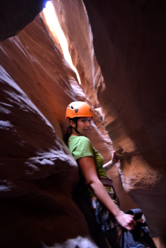
This is a view most Zion visitors will never have, but if you have the opportunity, take it. That’s me in a wetsuit and helmet in part of the underbelly sewer system of Zion in Pine Creek Canyon. This is a technical canyon that begins at the east entrance to the tunnel and ends a few switchbacks down the other side. It is dark, filled with pools of water that require wading or swimming, and rappelling when downclimbing is not possible. Parts of the canyon are visible to the less adventurous from a trail that begins at the east tunnel entrance. Seeing the path a former stream created is a beautiful thing.

1. Angel’s Landing

Angel’s Landing

The famed Angel’s Landing. Maybe you have heard of it because of its tricky trail up slick stone. Maybe you have heard of the thousand-foot drops on both sides of the trail when the trail is only a couple feet wide. Or maybe Walter’s Wiggles are calling your name.

Scout’s Lookout panorama, just before the final push to the end. I’m in grey, with the dark stone behind be the spine that needs ascended.

Whatever the reason is, this is the trail everyone wants to climb, even when everyone shouldn’t. There are real risks here. But most everyone still seems to love it, including me. It is not the highest trail, but I like that the walls are still high above me at the end of the trail. Everything surrounding me seemed much closer here than at Observation Point, for instance. I think it is the heart of the park. Just don’t stay at the landing too long, because you really do not want to hike down in the dark.

Posted in National park, National park, Parks, The Top Five, Utah | Tagged , , , , , , , , , | 1 Comment

Wednesday photo: Newspaper Rock

Newspaper Rock is so-called because of its plethora of petroglyphs. No one knows much about these ancient carvings, other than that they are younger than the painted pictographs. This ancient art is found all over the four-corner region.

Close-up on Newspaper Rock

This rock was either a meeting place or was a place that many tribes passed by. Or maybe it had some other meaning. There is no codex to explain the symbols, so no one can be quite sure.

And now for scale:

Posted in Utah, Wednesday photo | Tagged , , , , , , , | Leave a comment

Wednesday photo: Home, home on the range

I will be singing that song a lot over the next three days when I watch the buffalo roam and the deer and the antelope play.

Bison on Antelope Island in the Great Salt Lake

I am heading north to Wyoming and Montana to visit Yellowstone National Park and Grand Teton National Park, where I hope to spy grizzlies and wolves, along with the less elusive elk and moose. I will be checking out the geothermal features, too, which should include a soak in a hot spring.

Posted in National park, Parks | Tagged , , , , , , , , , | 1 Comment

The art of the Great Salt Lake: The Spiral Jetty

An earthwork sculpture in the Great Salt Lake, the Spiral Jetty created by Robert Smithson is an ever-changing piece of art. It was built from mud, salt, basalt rock and water in 1970 during a period of drought and then was covered for 30 years by a higher Great Salt Lake. Since then, the lake levels have changed back and forth more frequently, including from one season to the next, creating a piece of art always in flux.

I do not know how I first found out about the Spiral Jetty, but it was something my boyfriend and I discussed visiting for many months. The question of the lake level was what always kept us from making a two-and-a-half hour drive north, then west, and then south to Rozel Point. Of course, with the wealth of Internet knowledge, I found the measurement of the lake and that best viewing occurs when the water level is below 4, 195 feet.

We took a chance with a lake level of 4,195.7 feet. We did not know how much submersion there would be of the art, but we decided that even if it was entirely submerged, the lake water would be clear enough to view what it was covering.

I expected a barely visible coil white with salt. What we found was a somewhat submerged, grayish-black, counterclockwise spiral that was easily approachable.

Spiral Jetty at sunset

You could walk out a hundred yards without getting your toes wet.

Water flowing through the Spiral Jetty

From there, the hazy Great Salt Lake flowed in and out of the sculpture, leaving its calling card on the black stones. The stones showed lines from when the lake stayed at one level for an extended period of time. Others were covered in salt, which I expected to be crusty but was more like a sugary glaze on a cake.

We shared the Spiral Jetty with four other visitors from Washington for the first part of our visit and had it to ourselves the rest of the time. We passed no other cars on the dirt road portion of the drive. The Spiral Jetty is rather solitary. It is in a lake with such a high salt content that it does not support much life and the land around it is used for cattle ranches. And dedication is needed to get there since it is so far away from pretty much everything else.

But that just makes it more beautiful.

Some of the salty water was foamy even though there was hardly any water movement in and out of the sculpture.

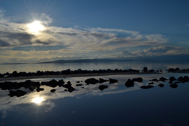
Rocks, clouds and land reflections

Sun and cloud reflections

Jon and I at the center of the sculpture

What to know before you go

The driving directions from the Dia Art Foundation, which received the Spiral Jetty as a gift from the artist, provided good enough instructions. We came up to the turns a bit sooner than projected, but there are signs, first to the Golden Spike National Historic Site in Promontory and then to the art. Golden Spike is where the first trans-continental railroad was connected with a golden spike on May 10, 1869.

Roads are paved to the historic site. Grated dirt roads take you the rest of the way. The dirt roads were in great condition and we cruised along quite quickly in a Jeep Liberty. A high clearance vehicle is not needed, although had we driven the Saturn Ion, we definitely would have driven much slower.

There are no facilities at the end of the road. The last bathrooms are at Golden Spike. The last gas is in Corinne, just off Interstate 15.

Bring water, snacks (for instance, Epic Brewing Company’s Spiral Jetty IPA or Beehive Cheese Co.’s Promontory cheese because I love eating food in the location it was named after!) and appropriate footwear. I wore rain boots and did not have to jump from rock to rock. Sandals or water shoes would work too.

Posted in Uncategorized, Utah | Tagged , , , , , , , , , | Leave a comment

Wednesday photo: Roses at Red Butte Garden

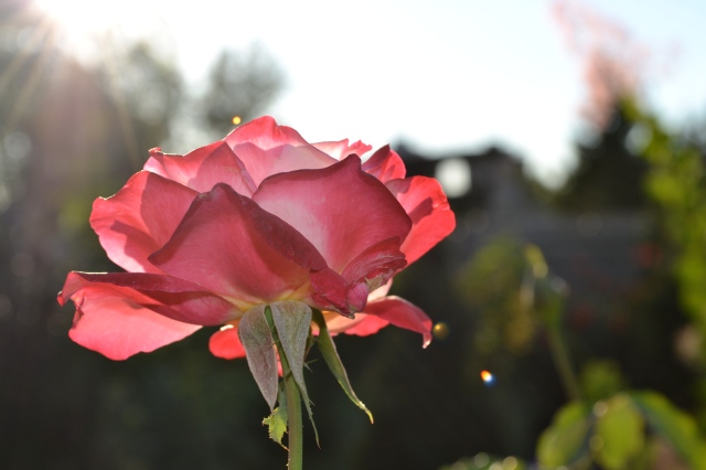
I love gardens. If I ever have one of my own, I want roses and fruit trees. For now, I get my rose fix at Red Butte Garden in Salt Lake City. I have been watching these roses since early summer and I return to the garden frequently to admire their beauty.

I love how long roses bloom!

I should have at least until the end of October to see the roses a couple more times. I am sure it will depend when winter arrives in Salt Lake City, because it snowed in the valley last year at this time.

Posted in Utah, Wednesday photo | Tagged , , , , , , , , | Leave a comment

Leaf peeping in the Wasatch

I didn’t start my drive to Provo Canyon thinking Utah’s fall foliage would put on such a show. I have high standards coming from Ohio, and the bit of fall I saw in Utah in 2011 was not memorable. I saw the aspens turning yellow, but where were the fiery reds and oranges I was accustomed to?

Maybe it is the drastically different winters the past two years. Last fall was coming off an extended winter and brilliant summer wildflower display. This most recent winter was less than thrilling leading to a summer with a lovely but not excessive wildflower display. Fall is definitely making up for it.

From my balcony I can see the brown-green east bench of the Wasatch Front dotted with reds, but trees on the valley floor have not yet given in to the end of summer. Up is where you have to go.

Bare aspens contrast with the dark red, orange and green around them on Pine Canyon Road in Wasatch Mountain State Park.

A customer at work told me about her recent drive through Provo Canyon to see the leaves, so when I had a chance, I decided to take my own trip south to Utah County and back up through Wasatch County, with stops to see Bridal Veil Falls along US-189, Sundance Resort, Midway and Heber Valley Artisan Cheese, where ice cream is available, with a return drive on UT-224 and UT-152 to Big Cottonwood Canyon’s east entrance.

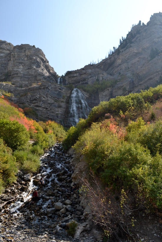
Bridal Veil Falls

Provo Canyon turned out to be too low to be saturated with aspens and instead was covered with other trees turning red and orange. It was lovely, and as I kept driving east, the leaves kept getting prettier.

Fall in Provo Canyon with Provo River

I turned up Alpine Scenic Highway UT-92 towards the Sundance Resort, and with the elevation gain and bright afternoon sun, the leaves continued to impress.

Leaves near the Sundance Resort on UT-92

I returned to US-189, driving around Deer Creek State Park and Reservoir and turning north onto UT-113 toward Midway. My adventures in Midway and Heber Valley Artisan Cheese are worthy of their own post.

The next section of my fall foliage drive was the most outstanding and I was not the only person out admiring the leaves at Wasatch Mountain State Park. Pine Canyon Road/UT-224 heads upcanyon through the park on a windy and narrow two-lane road without guardrails. Even I made sure to not get too close to the edge. There were occasional opportunities to pull over and admire the view.

Surrounded by color in Wasatch Mountain State Park

Meadow with changing leaves in Wasatch Mountain State Park

Be sure to stop at a wide curve to admire the trees and Heber Valley before the road heads into the mountains.

Heber Valley and Wasatch Mountain State Park panorama

The drive continues through the park for a few more miles before getting to private land in a dense aspen grove and then comes to an intersection where UT-224 heads east to Deer Valley Resort and Park City and a left turn heads west down Big Cottonwood Canyon Road.

The trees were not as varied in Big Cottonwood Canyon and I stopped only once, when the haze was enveloping the mountains.

Big Cottonwood Canyon haze

Big Cottonwood Canyon haze

What to know before you go

The drive took about five hours with frequent stops.

No admission fees are required for the drive or any of the stops I made.

It was a tough drive down Big Cottonwood Canyon into the sun without sunglasses, so be prepared.

Shift down when driving downhill for a safer drive.

The drive could be completed in either direction. I think it is easier to look at my surroundings when I am driving uphill as opposed to downhill, and the drive from Midway to Big Cottonwood Canyon had the most to look at, so I would suggest the directions I took with heading first to Provo and then north on the east side of the Wasatch.

Posted in Parks, State park, Utah | Tagged , , , , , , , , , , | 6 Comments